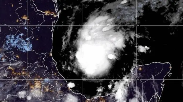
Tropical storm Isaias developed early on Wednesday, October 7, 2026, over the warm waters of eastern Mexico and is predicted to develop into the first hurricane of the 2026 Atlantic season, making landfall on the U.S. Gulf coast in the coming days.
The tropical storm was spotted around 285 miles west of Progreso, Mexico, and 580 miles southwest of the mouth of the Mississippi River, as per the Miami-based National Hurricane Center. The expected date of landfall is any time during Friday night or Saturday.
There has been no specific prediction on the point of landfall yet. According to National Hurricane Center, the area of possible landfall is likely to be anywhere from eastern Louisiana to the west coast of the Florida Panhandle.
"There is an increasing risk of damaging wind and storm surge impacts along parts of the northern Gulf Coast," stated the hurricane center, advising people from Louisiana to the Florida Panhandle to keep abreast of weather updates and make a hurricane plan.
There are projections that Isaias will continue to rapidly strengthen in the coming day or two. According to the National Hurricane Center, it could attain hurricane status on Thursday, then become stronger and reach at least Category 2 status by Friday evening over the central Gulf.
Wind shear has been noted by meteorologists as one of the factors that will play an important role in determining the intensity of the hurricane. Due to the projection of increasing wind shear with increased movement northward, some forecasters feel that it may weaken slightly before reaching the coastline with Category 2 hurricane – winds of 110 mph being the most likely at landfall. AccuWeather forecaster Alex DaSilva said that the current track of the hurricane does not pass through the wind shear, which means the hurricane should maintain its strength with wind gusts of 100 to 120 mph possible near the center of the storm.
The reason for saying that Isaias would be the latest first hurricane in a season in modern history is because, if it develops into a hurricane, it will break records, say several weather forecasters.
Isaias is the ninth storm of the 2026 hurricane season, which is a rather unusual slow start to a season which produces its first hurricane much earlier than October.
Aside from the wind speeds that are predicted to occur during this storm, there is also the possibility of large amounts of rain and the risk of flooding as Isaias makes landfall and begins moving inland.
The National Hurricane Center has predicted up to 3 to 6 inches of rain in the central Gulf Coast region extending from southeast Louisiana all the way to the Florida Panhandle region, with isolated areas receiving up to 10 inches of rain. Some forecast models also show that there is the possibility of this moisture being pushed to the Ohio Valley and northeastern regions by the mid-week next week.
Aircraft has been used in order to conduct reconnaissance missions on the storm in order to collect forecasting data.
Taking into consideration the current forecasted tracks, the area most at risk would be the Gulf Coast region, stretching from Louisiana, through Mississippi, Alabama and the Florida Panhandle.
Experts have warned that hazards associated with tropical storms tend to stretch well beyond the landfall area, especially on the eastern side of the storm, thus areas other than those close to the actual landfall point can expect major wind and rainfall impact.
As of Wednesday, however, the exact point of landfall and the exact strength at which the storm will make landfall are both still uncertain. Weather forecasters have expressed uncertainty with regards to the path of the storm and the speed at which it will be traveling.
Hurricane watches will be posted by the National Hurricane Center for the northern Gulf Coast, where Isaias will continue to strengthen. Track and intensity updates will be made until Thursday before the storm reaches hurricane status. People are encouraged to get their preparations done before the expected Friday landfall.