Cyclone Akvan may hit Coastal Andhra Pradesh before the province recovers from the previous one.
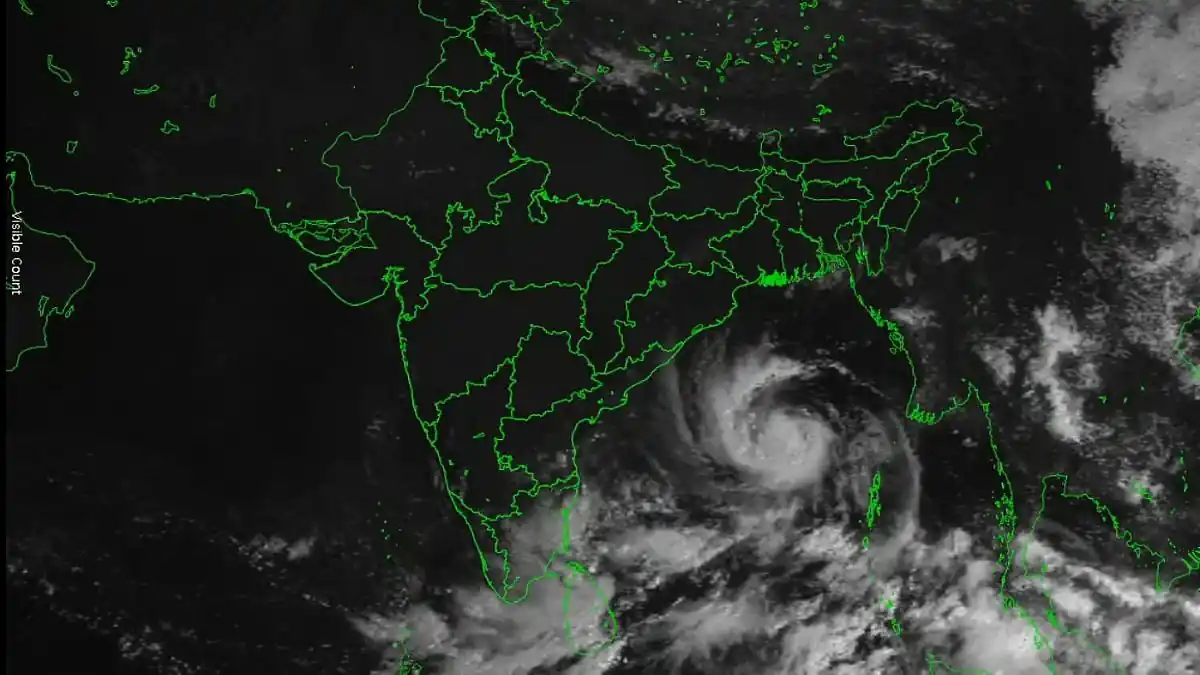
The weather system forming over the Bay of Bengal is likely to turn into Cyclone Akvan.
Andhra Pradesh will have to face yet another cyclone as a weather system forming over the Bay of Bengal is likely to form into a severe cyclonic storm that will head for North Andhra Coast by November 19.
This would mark the third cyclone of the season following Arnab and Murasu.
As of Sunday, November 15, the system remained quite far from any land mass. The system had its centre about 840 km east-southeast of Chennai, 1,010 km south-southeast of Visakhapatnam and 1,130 km south-southeast of Gopalpur.
According to the IMD, it is expected to intensify into a severe cyclonic storm in the west-central Bay of Bengal on November 17, and even further intensify into a very severe cyclonic storm by November 19 morning. The headline in the Odisha Bytes report predicted wind gusts up to 145 kmph on November 19.
It must be noted that the intensity forecast is just an estimation.
It has not been determined where the storm would make its landfall. "The exact place of landfall has still not been decided as the storm is currently taking an unusual course as per IMD projections," said Prakhar Jain, managing director of the State Disaster Management Authority.
Models have shown differences in their prediction. While some predicted the Andhra coast in the region between Visakhapatnam and Gopalpur in the timeframe of November 17-18, others predicted the north coast of Tamil Nadu in the region of Chennai by November 19-20.
There will be heavy to very heavy rain on November 18 and 19, and the IMD has already raised an orange alert for the area. It will see heavy to very heavy rainfall in all of the north Andhra coast, and some places will see very heavy rainfall.
It has previous experience with this kind of natural calamity. Cyclone Arnab hit the coast this month, and there were no fatalities recorded during this time.
Rain is expected to reach the north too. For November 19-20, the IMD has forecast a warning of very heavy rain for the districts of Gajapati, Ganjam, and Puri. In another update, it has included the district of Rayagada as one which might witness heavy rain on November 19.
However, the Regional Meteorological Centre has tried to placate the south. According to the centre, the cyclone is moving towards Andhra Pradesh and Odisha states; hence, Tamil Nadu should experience light showers in some parts of the south and hilly areas. The prediction may vary depending on the path, considering the divide among models.
Those living in northern parts of Tamil Nadu state should monitor the IMD predictions.
The news item that triggered this news story talks about the rains in Bengal. None of the articles referred to above provides any kind of forecast regarding West Bengal.
Another news article indicated that one thing to be considered about the cyclones of the season was whether they were influenced by climate changes like El Niño and warmer oceans. This is simply speculation; there is no analysis found in the articles reviewed that associates Akvan with any cause.
A few steps are common practice. The fishermen need not venture out to sea, the coastal regions need to arrange for shelter, and people living in low-lying areas need to be prepared to evacuate upon instructions. None of the information available in the reports so far includes any mention of evacuation warnings, as the cyclone has not yet developed.
IMD and the Cyclone Warning Centre in Visakhapatnam are tracking the system. In one or two days, the track will become clearer.